Less frequented by tourists than its famous neighbors, the island of Kea in the Cyclades is an ideal destination for a weekend getaway. Plus, the island has lions!

We chose to visit the island on a quiet weekend at the end of May. You will notice a yellow tint overlaying every picture in this article. This is because at that time Greece was covered with a sand blanket that the wind blew over from the Sahara desert. This phenomenon used to be a rare occurrence, but it tends to appear more often due to climate change.


Kea is also known as Tzia, the two names usually being presented in the convention Kea (Tzia). The name Kea claims its origin to the hero Keos, the head of settlers from Nafpaktos who in ancient times occupied the island. In 1204, when the Venetians conquered the island they named it Zia, which was then converted to Tzia. We boarded the ferry boat from the port of Lavrion (not Piraeus), a smaller port that is accessible only by bus or car from Athens. An hour later, we disembarked at the port of Korissia or Coressia. Kea is renowned for its extensive network of hiking trails, which crisscross the island and connect its major attractions. Two dancing troupes and a hiking group were traveling with us on the ferry boat.

For a couple of decades now, Kea has been the summer home of many “indigenous” Athenians, the ones who do not have roots in some random village in the Peloponnese. There are a lot of summer houses and only a few hotels, so take that into account when visiting. Or you can follow the rich guy route instead, since the island’s ports are also hosting a lot of comfortable sailing boats belonging to wealthy visitors. You can notice the effect of such a high-income tourist base at the island’s restaurants and shops, especially around Vourkari.


After we arrived, we waited a bit for the afternoon to come and started walking on a path along the coastline, towards the beach towns of Galiskari and Vourkari. At some point, we came across a flock of geese, hens, and cats who were simultaneously trying to hide from and to pursue us. The landscape is barren, covered only by low bushes. During spring we noticed a myriad of blooming amaranths in purple and yellow colors dotting the landscape.


The bay of Vourkari ends at a small protruding peninsula. At the neck of the bay, lies the abandoned industrial area of Kokka. From the end of the 19th century until the beginning of World War II, the island served as a crucial coal and coke supply station (that’s where the name comes from), significantly contributing to its economy. Today, the coal depots and central supply dock lie abandoned and weathered by time. There are no shops for food or drink after this checkpoint, so I recommend getting supplies from Vourkari.

Just after passing Kokka, the thin strip of land is called “the Strait of Lambros Katsonis”. Katsonis was a famous Greek sailor, who in August 1789 took advantage of the low altitude of the land and achieved a very impressive feat. He sailed his ship over the narrow passage of land and escaped from the Ottoman Turks who thought they had trapped him inside the large bay. Kea was his main base, where he met his wife. Until June 1789, Katsonis controlled with his ships the whole Aegean Sea and tried to convince Greeks against paying taxes to the Ottoman emperor and to start a revolution. This is what caused the sultan’s wrath in the first place. Instead of surrendering, Katsonis dragged his ship over the narrow strip of land using tree trunks smeared with pig fat and escaped to the open sea. This is a similar method to the one that ancient Greeks used to pass their ships across the Isthmus of Corinth in the Peloponnese.

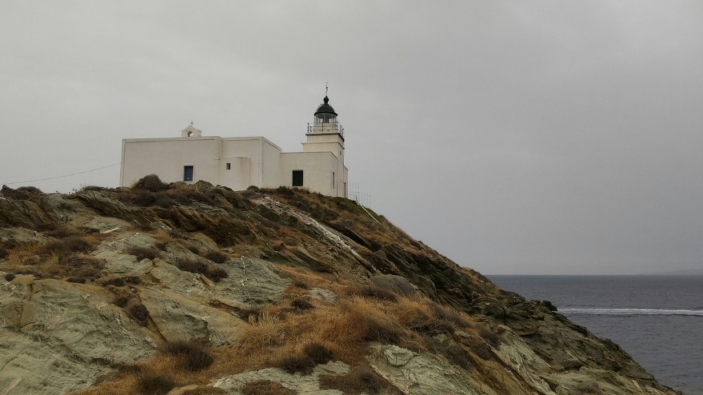
At the tip of the peninsula stands the solitary lighthouse and the adjacent church of St Nicholas. From this spot you can observe the interior of the bay, as well as the island of Makronisos. At the beginning of the century Makronisos was used as a place of exile for prisoners of war (1912/13) and later as a place of convalescence for some of the Greek refugees of the Asia Minor disaster (1922) who had contracted typhus. From 1947 to 1974, the island was used as a military prison and re-education camp for political prisoners, particularly communists and leftists, during the Greek Civil War and the subsequent military junta. Thousands of detainees were held in harsh conditions, undergoing forced labor and indoctrination. After looking at the sea for a long while, we returned back to the port from the same path, after a quick soak at the Gialiskari beach.

Another super short hike starts from the main town of Ioulida. A bit more colorful than the other Cycladic towns, Ioulida is beautiful in its varied decor. The town was one of the four city-states of Kea during antiquity. The Venetian Castle, or Kastro, at the summit of the town, built in the 13th century is a prominent landmark. The streets are narrow and covered with cobblestone, so no cars can pass through.


In Ioulida’s urban houses, the basic structure features a two-storey rectangular main building adjacent to a roof area called “stegadi”, with access to the ground floor shop “magazes” through the roof. The roof’s architectural use, influenced by rural homes, varies with conditions and needs, sometimes functioning as a passageway or providing scenic views.


Aristides, one of the seven great sages of antiquity, hailed from Kea and gained fame throughout Greece for his strict and exemplary laws. One such law, mandated that citizens over the age of 70 who could no longer contribute mentally or physically to the state had to explain their decision to commit suicide to the state’s lords and then were allowed to do so using hemlock. This custom ceased with the rise of Christianity in the 3rd century BC. The poet Simonides (556 BC-468 BC) also came from Kea. He is notable for being the first poet to write commissioned poems for payment.


According to legend, the island was once known as Hydroussa, named after the water nymphs who resided in its lush forests and springs. The gods, envious of the island’s beauty, sent a lion to drive the nymphs away. As they fled, Sirius, the brightest star in the sky, cast its harsh rays over the land of Hydrousa and all the Cyclades, causing a severe drought.


The inhabitants, desperate for relief, sought help from the demigod Aristaeus from Thessaly, the son of Apollo and the nymph Cyrene. Aristaeus led the Arcadians to Kea and offered sacrifices to Icmaeus Zeus, the god of rain. The gods were appeased, and the drought began to subside. Since then, the north winds, known as the meltemia, blow for 40 days each year during the period when the constellation Canis Major, which includes Sirius, is visible. Aristaeus settled in Hydrousa, teaching the inhabitants agriculture, animal husbandry, and beekeeping, and establishing religious practices. Later, the hero Keos, son of Apollo and the nymph Rhodesis, arrived, giving the island its current name. The connection of the island to the god of the sun remained strong even in the mythical era. Surprisingly, that part of the town reminded me a lot of my hometown’s architecture in Arcadia, Peloponnese. Maybe that’s the legacy of Aristaeus.


On the path that starts from the area of Agios Spyridonas and ends at the bay of Otzia, you will meet the famous Lion or Leon, the island’s trademark. It is an archaic sculptural monument of the 6th-7th century BC, carved into a solid slate rock about 8 meters long, and is associated with the drought myth. Another legend associated with this lion goes as follows. For some unknown reason, fairies came out of the sea and killed the women of the island. The inhabitants prayed to Zeus who sent a lion to chase away the nymphs. When the lion fulfilled its mission, it sat down and turned into stone.


Apart from the port and Ioulida, the archaeological site of Kartheais worth visiting , but requires an hour-long hike to do so. One of the most popular trails starts from the capital Ioulida and reaches Karthea. This hike passes through terraced fields, and the ancient oak forest, finally reaching the ruins of Karthea overlooking the Aegean Sea. Moreover, Kea is a unique destination for divers as there are four very interesting shipwrecks nearby: the sister ship of the Titanic, HMHS Brittanic, the French ocean liner “S/S Burdigala”, the wheeled steamship “Patris” and a German plane Junkers 52 of World War II.

The trails that I followed during my excursion are a) Korissia Port -> Gialiskari Beach -> Kokka -> Lighthouse loop, and b) the beginning part of Ioulida – Lion of Kea – Otzias from alltrails. The trail to Karthaia is Ioulida – Karthaia (Megales Poles) Beach, although I recommend getting a bus or taxi and catching the trail only at its last part. Be extremely wary about the scorching sun and the lack of water or shadow along the trails. You can read more hiking posts under the tag hiking. If you liked this article, share it with your friends. You can also follow this blog, and follow me on Instagram or Facebook, to never miss a post. Until next time!


Read more:

Hiking in Greece: Hermes playground at Mt Ziria
The Ziria mountain range is home to the second tallest peak of the Peloponnese. Taygetus is first, Ziria…
Keep reading
Hiking in Greece: The many gorges of Samothraki
Last summer, I had the most amazing summer vacation experience: no electricity, no water, no cash, no internet,…
Keep reading
Hiking in Greece: Hunting for statues in Naxos Island
I know, it’s probably a cliché thought in the heart of winter, but let’s take a stroll back…
Keep reading