[Visited on January 23rd, 2022]
By now, Mt Mitake is probably the mountain that I’ve hiked the most, already five times. I always come across the sign that leads to Mt Otake, but I’m usually short on time with the sunset looming. This time, I decided to take the cable car up to Mitake in order to save some time and then hike my way from Mitake (御岳山) to Otake (大岳山).

The hike mid-winter is gloomy and dry. A lot of fallen leaves are obscuring danger on the path, but luckily there was no snow, just the occasional frozen mud. After passing Mitake shrine, I got a glimpse of the view at the Nagaodaira observatory (長尾平展望台), headed back to the intersection in front of the Nagao cafe and took the higher path of the two, on the right. Last time I was at that point, I was running away from a wild boar, so be sure to keep your guard up. This time, though, the mountain was crowded with humans, no boars in sight, so I quickly reached a stone torii gate and again took the high path on the right. We will climb Mt. Nabewari en route to Otake.


Expect a path with steep ups and downs which follows the ridge. Large trees are sheltering the hikers and their roots double as steps. I climbed the stone stairs to the Ogunashiya (男具那社), a well-preserved vermilion shrine. Legend has it that when prince Yamato Takeru was lost in this area, a white wolf appeared to help him. So he ordered the wolf to become the guardian of the area and a messenger to god Otake. He also devoted his armour to this shrine. From this point there is a view to Tokyo bay. Takeru looked towards the sea and thought of his late wife exclaiming “我が妻よ” (=ware ga tsuma yo), so the place came to be known as ‘Ajuma’.


Ogunashiya shrine is related to Oku-no-in shrine a few meters above, at 1077m altitude. Some believe that Oku-no-in was the original location of worship for Mitake shrine, which was afterwards moved to its present location. It seems that the mountainous landscape is similar to that of Mt. Yoshino in Nara, which led to similarities in terms of pilgrimage locations and the propagation of the Zao faith. Unfortunately, there is not much flat area to rest around Oku-no-in, so I kept going up to reach the top of Mt Nabewari (鍋割山) at 1084 m. This peak got its name due to its shape, because it looks like the lid of a pot (=nabe), and it is a landmark for fishermen in Tokyo bay. The path is a common pilgrimage route for the Yamabushi (the travelling monks) and I also met one just after Nabewari. You can spot them from their white robes, their headscarf and from the jingly staff that they carry.


Now, we come to the fun part. After Mt. Nabewari the path becomes increasingly steep with dangerous foothold. At some parts, there are chains to support yourself. After a few more ups and downs, I eventually reach another torii gate. To the left, I can see the location of the old Otake mountain hut, which has remained closed since 2008. It used to be a large complex of buildings, including a heliport for provisions. The observatory is at risk of collapsing, so it is off limits. I am not sure if it is currently being repaired or just prevented from absolute decadence. A prominent but weirdly shaped roof is an abandoned Taiwan temple (台湾寺院), whose priest died and left the building to decay. The mountain hut was managed by Tokyo’s metropolitan government, which is also evident by the signs at the public toilet. For some reason the marks for male/female bathrooms were marked with swiss-style hats, I wonder how this design came to be.

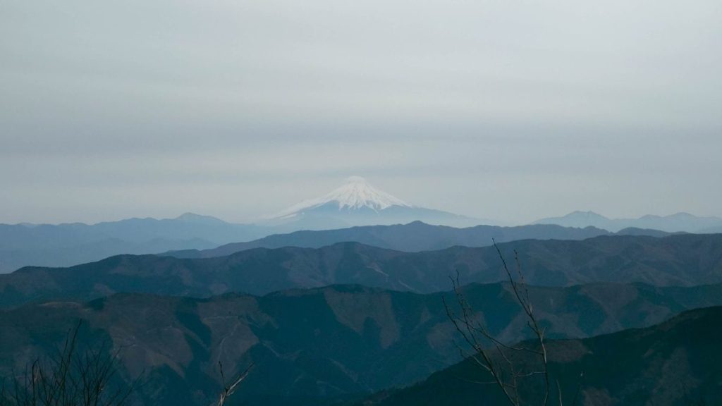
The god of Mt. Otake is a wolf, similar to the nearby Mitake shrine and Mitsumine shrine in Chichibu. The path continues next to inner Otake shrine (大嶽神社奥宮) and this last part to the summit is the steepest. Be aware of your footing and keep going, you will be rewarded by a marvellous view of Mt. Fuji at the top. Mt. Otake stands 1266.5 meters tall. Here there are a few benches to rest and relax. I was lucky to come across relatively clear atmosphere, with the entire southern mountain range of Kanto visible in detail. If you want, from here you can follow a path that leads to lake Okutama, although I returned back to Mitake, although skipping Nabewari this time.


At the Nabewari intesection, I took the right path to Ayahiro falls. The entire Kanto sustained serious damage during typhoon Hagibis in 2019. The problems caused at that time are still visible, with some sections of the path still cut off 4 years later. Luckily, the rest area close to the falls is fully restored. Last time I was here, a week after the typhoon, this point was the furthest I could go. Bridges and sections of the path had collapsed and it was impossible to reach Mt. Otake. Now the path is not perfect, but easily passable.


Back to Mitake shrine, I bought myself some wooden disks to use as coasters, because they smell like the forest. I said hi to the dogs who were washing their paws in the water fountain at the entrance to Mitake shrine and walked to the bus stop instead of taking the cable car.


You can check the route at alltrails. If you are interested in the area of Mt. Otake, read my other articles about Mt. Mitake and Chichibu. Next time, I’ll show you around Mt. Imakuma and Kongo falls.

Read more:

Day hike from Tokyo: Mt. Mitake, Hinode and Konpira
During the peak of the first wave of the Covid-19 pandemic, people of Tokyo were asked not to…
Keep reading
Μονοήμερη εκδρομή από το Τόκυο: Πάμε Τσιτσίμπου;
Ξέρεις να μου μια λέξη με δύο τσι; Δύο προφανείς επιλογές είναι το τσιτσί και ο Τσιτσιπάς. Έρχομαι…
Keep reading
Tips about hiking in Japan
As every Japanese person is surely going to inform you, ‘Japan has four seasons and the most amazing…
Keep reading