[Visited on February 5th, 2022]
OK guys, this will be a short one. This is a hike for the days that you want to go out, but don’t feel like trying too hard. Today we will head out to Mt. Imakuma (今熊山), which contrary to what the name suggests, has no bears present at the moment (Ima=now, Kuma=bear for the ones who happen to miss the joke).

To reach the trail, you need to first reach the middle of nowhere, i.e. Totohara in Akiruno city of Tokyo. Get off at the bus stop at Komine Park and start going up. The park is large, popular for families and even features a tiny flying fox, suitable for children. You can enjoy the early spring blossoms or move forward to the forested area. Just follow the path until you reach the end of the park and a sword-like mark of the goddess of mercy, Kannon. Specifically, this one is devoted to Bato Kannon (馬頭観音 in Japanese, hayagriiva in Sanskrit), a rare depiction of the goddess with the head of a horse. While she is generally displayed as a graceful lady, Bato Kannon is fierce and formidable, a necessary attribute when you need to look after travellers in the woods. Simple stone monuments next to the road, with her name like this one, are used to commemorate the location where a horse died unexpectedly.


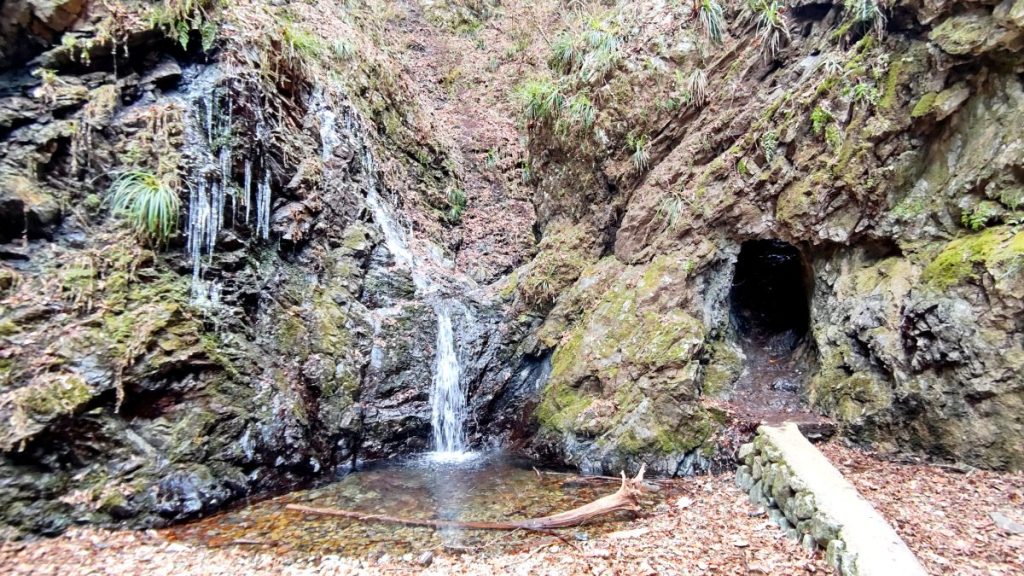
Our next stop is Kongo falls (金剛の滝). The water falls from about 20 meters height, ends up in a small pond and then forms another waterfall. A tiny tunnel carved inside the stone takes you to the inner waterfall. Next to it, you can see stalactite formations in winter, as well as a statue of its guardian, Kongo Rikishi. I wonder if it was covered with leaves, because I never found it. Maybe the guardian had a day off on the day of my visit. What I could see, though, was the figure of Fudo Myo-o, a Buddhist saint, just next to the main waterfall. There was a metal staircase nearby, but unfortunately the path was inaccessible, so I have no idea where it leads.
affiliate offers
- Hike Mt Mitake comfortably with Wabunka
- Adventure in Aegina: self-guided tour with AR puzzles — from 12€/group.


Follow the signs to Mt. Imakuma, and you’ll soon reach the backside of the homonymous shrine. A white torii gate stands in front of Imakuma shrine and a picnic table is located conveniently nearby. The mountain is just 505.7 meters tall, but from here, you can get a clear view of Tokyo. The Skytree and the skyscrapers of Shinjuku are easily discernible. Mt. Imakuma is nicknamed “Yobari-yama” or “call-out mountain”. Apparently, if you climb up the mountain and ask it to bring back something you lost, either a person or an object, the mountain will gladly help. I tried asking for my missing necklace, but had little luck. I found dozens of shattered inari figurines behind the shrine, maybe they messed with my luck.


From here, you can either grab lunch and head back, or follow the ridgeline to Mt. Kariyose (刈寄山). The landscape becomes more mundane as you go, since the mountain is being heavily capitalized upon. On the left side of the path there’s a stone mine, while on the right side a lot of trees are cut down for forestry. However, by the time you reach Mt. Kariyose, the forest becomes untouched again. On the top of Mt. Kariyose, you can find yourself completely alone in the mountains, since it’s one of the less crowded nature spots in Kanto.


A recommendation for hiker-campers is to continue from Mt. Kariyose to Mt. Jimba. However, that route is considerably long, therefore I returned the same way as I came. Since I visited the trail at the end of winter, everything looked dry and dusted. I’m pretty sure that especially Kongo falls will look amazing covered with the lush greenery of the summer.


You can check the route at alltrails. It’s 12 km long with about 800 m elevation gain, and takes about 5 hours to finish. Next time, I’ll show you around Mt. Bonoore and Shiratani falls. In the meantime, read about other quick hikes around Tokyo.
Read more:

Day hike from Tokyo: Mt. Mitake, Hinode and Konpira
During the peak of the first wave of the Covid-19 pandemic, people of Tokyo were asked not to…
Keep reading
Tips about hiking in Japan
As every Japanese person is surely going to inform you, ‘Japan has four seasons and the most amazing…
Keep reading
Day hike from Tokyo: Mt. Otake
I always come across the sign that leads to Mt Otake, but I’m usually short on time with…
Keep reading