When it finally snows around Tokyo, an issue arises: Where to hike to next? Well, there’s this little ridge right on top of the border between Tokyo and Saitama prefectures. Tucked inside the mountains, Bonoore ridge is accessible all year round. It is one of those routes where the journey is more fun than the destination.

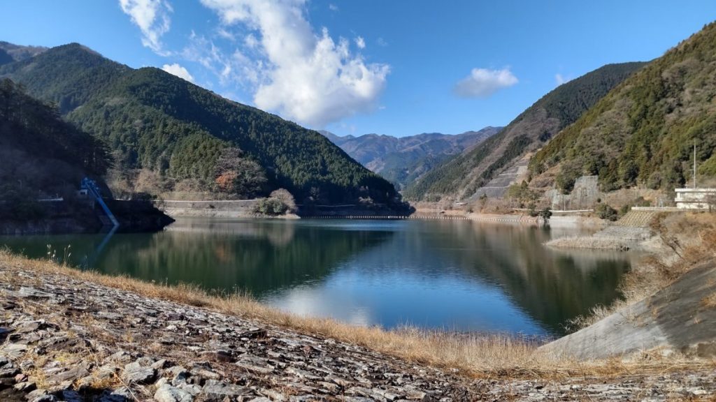
The starting point to reach Bonoore ridge (棒ノ折山) is at lake Naguri (名栗湖). The lake was formed after the construction of the Arima dam and serves as a water reservoir. It is an ideal location for weekend activities: there’s a canoe workshop, fishing spots and a barbeque area. Naguri lake is also famous for its firefly viewing event in the summer. Nolla Naguri (ノーラ名栗) with tent saunas is ideal for Nordic aficionados, while Sawarabi onsen is more geared towards traditionalist enjoyers of hot springs.


Bonoore means “the stick that got broken”, because according to the legend that’s what happened to warlord Hatakeyama Shigetada, when he was crossing the ridge. Shigetada was a powerful samurai at the area of Chichibu. In the legendary Genpei wars, he stood originally on the side of the Taira clan, but midway decided to switch to the eventual winners, the Minamoto clan. After the war, the Minamoto cousins clashed for the throne. At that time, during the battle of Awazu, Shigetada was assigned and failed the task to capture Tomoe Gozen. She was a female samurai, technically referred to as onna-musha (女武者) and a fearsome opponent. Unfortunately, women’s issues persist through the ages: Tomoe’s master Minamoto no Yoshinaka sent her away from the ending moments of a battle, because he would be ashamed if he died next to a woman.


The hiking path goes around the lake and then turns towards Shiratani valley (白谷). Walking among the tall cedar trees in a serene forest has a calming effect. Soon, the root staircase gives its place to rocks and streams. Be sure to wear bright clothes when hiking in winter, because the area is popular for hunters during the hunting season.

At some points, you may need to climb vertically on rocks and use ropes to move forward. The path gets especially dangerous after the rain, when slippery mud covers everything. At the top of Mt. Bonoore you can see a sign that marks the 869m elevation. Clear skies might grace you with a full view of Tokyo, as well as the Chichibu mountains.


There are some benches at the top and close to pretty rocks, where you can rest and grab lunch. Apart from that, the landscape doesn’t change much on the way back. Since the hike takes less than 4 hours to complete, there’s plenty of time left to relax at the onsen or arrange a BBQ session. It seems that this area used to be popular, but not so much anymore, so peace and quiet are guaranteed.


If you want to check out the details of this hike, you can follow the route in alltrails. If you liked this article, share it with your friends. Do you have any hiking tips for the area? Add them in the comments. You can also follow this blog, follow me on Instagram or Facebook, to never miss a post. Until next time!
Support this blog | Στηρίξτε το blog
Read more:

Day hike from Tokyo: Mt. Mitake, Hinode and Konpira
During the peak of the first wave of the Covid-19 pandemic, people of Tokyo were asked not to…
Keep reading
Μονοήμερη εκδρομή από το Τόκυο: Πάμε Τσιτσίμπου;
Ξέρεις να μου μια λέξη με δύο τσι; Δύο προφανείς επιλογές είναι το τσιτσί και ο Τσιτσιπάς. Έρχομαι…
Keep reading
Day hike from Tokyo: Imakuma Shrine and Kongo Falls
Today we will head out to Mt. Imakuma (今熊山), which contrary to what the name suggests, has no…
Keep reading